
All About Drone Imaging
By John Pirrung, Field Support Specialist, SWNYDLFC
I've been lucky to spend a good chunk of my summer becoming a drone pilot for the team, and we're finally starting to get some opportunities to fly our drone out to fields and collect some data from our neonicotinoid research plots. As we learn more and gain a better understanding of how drone imagery can help growers make management decisions, I plan to share it all in articles like this one.
Drone Imaging Technology:
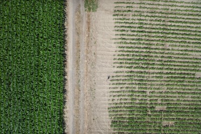
Our main goal when using drone imaging technology is to get a spatial snapshot of the health of a field, identifying which areas are doing well and which areas are in need of some help. This snapshot map is created by combining different types of camera technology with different measurement metrics called vegetative indices. A vegetation index (VI) is a calculation that takes photographic information about different wavelengths of light reflected by plants in order to estimate the health of those plants.
Compared to satellite or tractor-mounted imaging technology, drones have several advantages. They can be flown close to the ground and can capture very high-resolution images while still staying above the plants and out of the field. They are also generally easier to deploy and can have more flexible timing, though strong winds can delay flights and heavy cloud cover can make it more difficult for aerial cameras to take accurate photographs.
There are two main types of camera technologies used when imaging field crops:
• RGB:
- Standard red-green-blue digital camera technology, like the kind your phone camera uses
- Good for scouting and identifying basic issues like water pooling, stand gaps, or patches of weeds
• Multispectral:
- Captures near-infrared and red-edge wavelengths of light that human eyes can't see
- Necessary to calculate vegetative indices like NDVI or NDRE, which can help you measure canopy vigor
Generally speaking, healthy plant tissue will reflect near-infrared light and absorb red light. Vegetative indices like NDVI and others measure the contrast between the amount of reflection and absorption identified in the aerial imagery. Different indices excel in different situations; for example:
• NDVI - Measures plant vigor, vegetation density, overall "greenness"
• GNDVI - Measures nitrogen status and chlorophyll levels, helpful for early stress detection
• NDRE - Measures vegetation health and chlorophyll levels, and can handle dense canopies
There are many other indices that can be used depending on the imaging technology (ex. satellites) but these are ones you're most likely to see chosen in agricultural contexts. For the most comprehensive results, multiple flights can be taken with different cameras attached and analyzed with different methods, providing as much information as possible to inform management decisions.
Who Can Actually Fly?
Any flight used to monitor anything about your farm (stand counts, weeds, wet spots, etc.) all count as commercial flights, even if no money changes hands. In order to fly a drone for commercial purposes in the US, you must be certified as a commercial drone (UAV) pilot under FAA Part 107. This involves completing a course, passing an exam, and registering your drone online with the FAA, all of which have associated fees and recurring requirements. And of course, the drones and cameras vary wildly in price, but most cost several thousand dollars for a full kit, and recent FCC rulings have complicated the market by banning certain foreign-made drones. With all that being said, many farmers will likely find it much more convenient to hire a local drone service instead of operating their own. Though, if you are interested in using a drone yourself, supplemental grants may be available depending on your use case.
Turning Images Into Data and Decisions:
Once you have the raw images taken by the drone camera, the images can be stitched together with software to create large, high-resolution, color-coded maps. The final product will look different depending on the vegetative index used, but generally you'll be left with a heatmap showing healthier areas in green and stressed/less healthy areas in red.
It's important to know that the maps created through drone imaging can be extremely detailed, but in the end they can only show you *where* a field is struggling, not *why* it's happening. Most of the time a drone can tell you specific areas of your field that you should take a closer look at, but it can't replace boots-on-the-ground scouting when it comes to actually diagnosing the cause of the issue. For many growers, drones can work hand in hand with ground scouting for certain issues, saving time by helping you prioritize which areas need more attention.
So, what issues can drones help you identify? Basically, anything that visibly reduces chlorophyll content, canopy density, or plant height. This includes:
• Water-related stress (ponding, drainage issues, drought stress)
• Nutrient deficiency (nitrogen deficiency is particularly visible)
• Mechanical issues (uneven fertilizer applications, gaps from planter skips)
• Soil issues (compaction, erosion, variation from soil types within a field)
• Pests and disease (insect feeding, disease pressure, weed patches)
In all of these cases, the drone imaging, whether you're using NDVI maps or just regular RGB photos, can help you identify areas where crops are struggling, and can maybe even give you some idea of the cause. However, you'll still want to check out the area in person to ensure that you've properly confirmed the cause yourself. This may involve collecting additional data like soil samples to understand why the plants are struggling.
Either way, by narrowing down specific areas facing issues, you can be sure that you aren't wasting time or resources by treating areas that are doing fine. Like most precision ag technology, drones allow you to identify specific areas that need specific inputs, instead of just doing a blanket treatment. And in cases that involve spray treatments, it doesn't matter what you're spraying, you can save time and money by only treating the areas that need it.
The Big Picture:
Drones and drone imaging can provide a whole new view of your fields and can generate massive amounts of data to help inform your decisions. However, like most new technology in ag, drone imaging will be most helpful when used in tandem with traditional scouting on-foot, helping you scout more efficiently and highlighting problem areas you may not have been aware of.
Personally, I find it really fun to just be able to see everything from a bird's-eye view. Even with modern satellite mapping, nothing beats a live feed from a drone flying 100 feet above a field. It provides a whole new perspective and makes it easier to see large-scale differences that would be almost impossible to see at ground level.
Resources: https://www.sciencedirect.com/... https://blogs.cornell.edu/what... https://extension.illinois.edu... https://www.pubs.ext.vt.edu/co...
Field Crops
Dairy
Business
Livestock
Grains
Upcoming Events
Poultry Processing Workshop, Canandaigua, NY
September 17, 2026 : Poultry Processing Workshop - Canandaigua, NY
Canandaigua, NY
This program is one of four statewide roadshow stops across the state, offering farmers a full poultry processing experience. The class will teach skills that build confidence, reduce costs, and strengthen your farm's independence. This hands-on workshop gives farmers the chance to process a bird from start to finish, learning every step of the workflow used by small farms across the state.
Tax 101: An Introduction to Income Taxes for Farmers
September 17, 2026 : Tax 101: An Introduction to Income Taxes for Farmers
Join NY Farm Net for a FREE mid-day webinar about income tax basics for farmers. Attendees will learn what documents you need, options for recordkeeping systems, how identify common tax forms and schedules, and more!
Large Animal Awareness Training For First Responders
September 19, 2026
Dunkirk, NY
Join the Chautauqua County Technical Rescue Services and NYS Veterinarian, Dr. Kate Card-Allen, for a specialized training on how to safely and effectively respond to large animal incidents. Learn techniques for managing large animals during traffic accidents, rollovers, entrapments and other transportation emergencies.
Announcements
No announcements at this time.